
Project Highlights
- The Matuka license 34992-HQ-LEL is wholly owned by Iimba Enterprises Ltd (Zambian Company), was granted on 26th April 2024 for a period of 4 years.
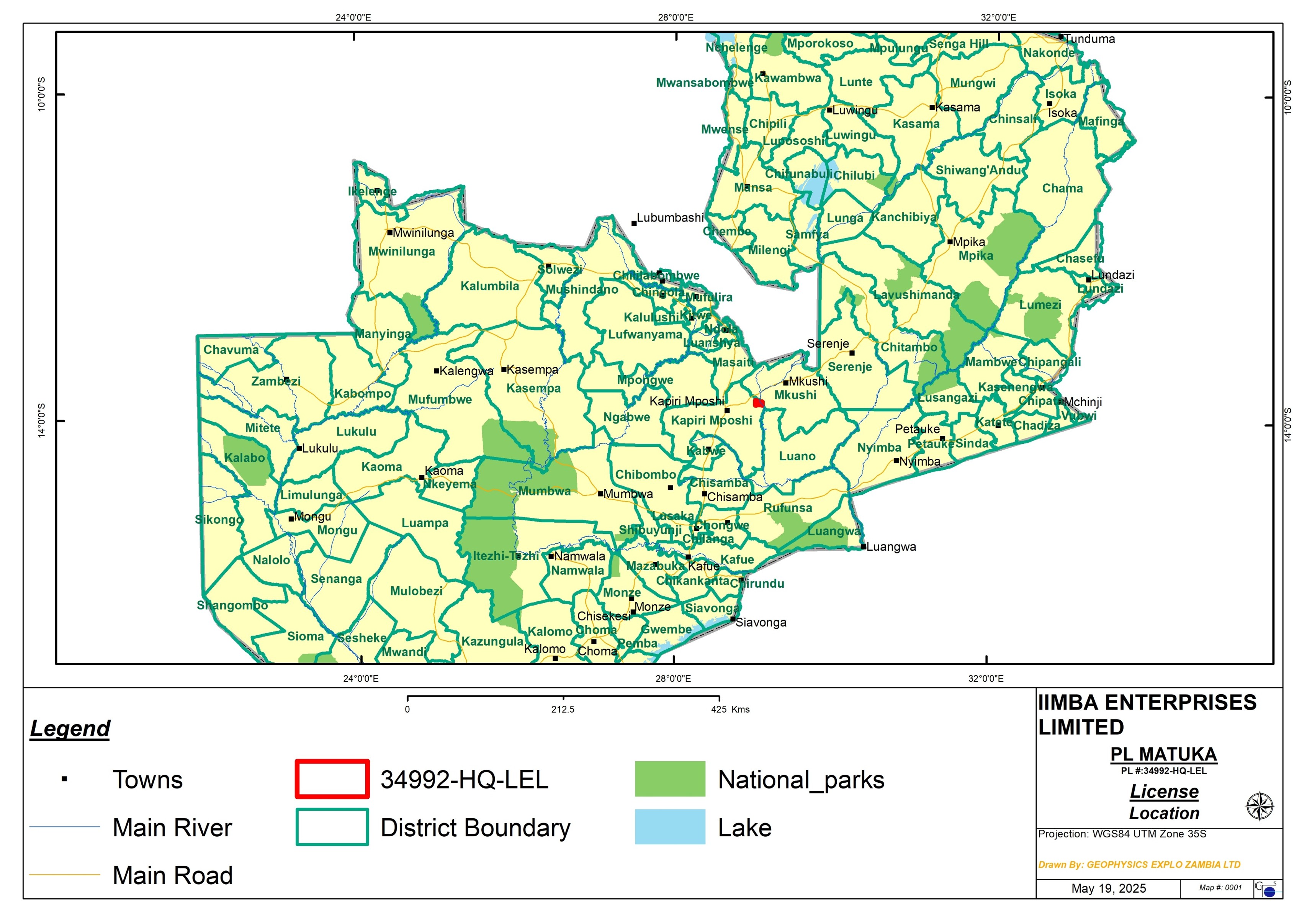
- Matuka project is located on the boundary of Mkushi and Kapiri Mposhi Districts of Central Province of Zambia, about 34km NE of Kapiri Mposhi town and 35km SW of Mkushi town.
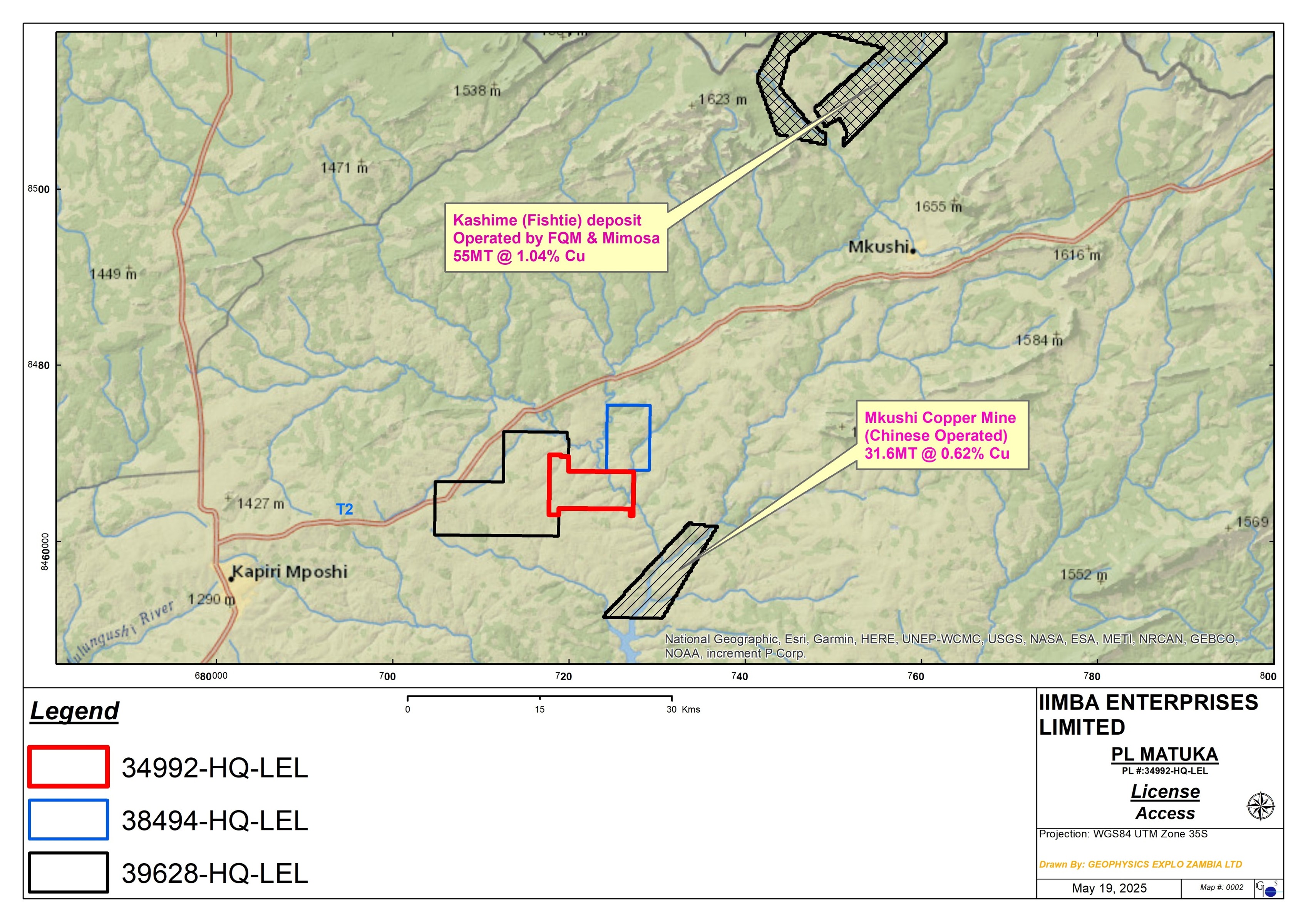
- Located about 10km NW of Mkushi Copper Mine (31.6MT @ 0.6% Cu), currently being mined by a Chinese company.
- Located on the southern end of the Irumide Belt, a Mesoproterozoic fold and thrust belt, dominantly underlain by fine grained gneisses and porphyroblastic gneisses of the Mkushi Formation.
- Historically the Matuka area was partly covered by exploration by African Eagle Resources of UK who explored the Mkushi area between 2007 – 2010 with a focus on Mkushi Copper Mine. African Eagle some limited soil geochemistry and IP surveys around the Matuka area but did not do any drilling despite having generated some drill targets because they pulled out of Zambia.
- Iimba Enterprises acquired the African Eagle exploration data and continued where they left. To date Iimba has completed detailed soil geochemistry, IP survey, ground magnetic surveys, radiometric surveys, topographic surveys. Drill targets have been generated from these works, a potentially 3.3km strike of Cu-Pb-Zn anomaly associated with an IP anomaly has been defined.
- 8 diamond drillholes totaling 1,749.6m. 7 out of the 8 drillholes intersected Cu mineralisation associated with appreciable grades of Zn.
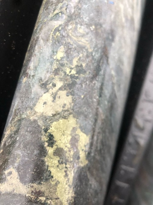
- Main Cu mineralisation is chalcopyrite that occurs with pyrite in disseminations, veins, along foliations and massive blebs on fracture plains. Mineralisation is hosted in altered and sheared gneiss/schist.
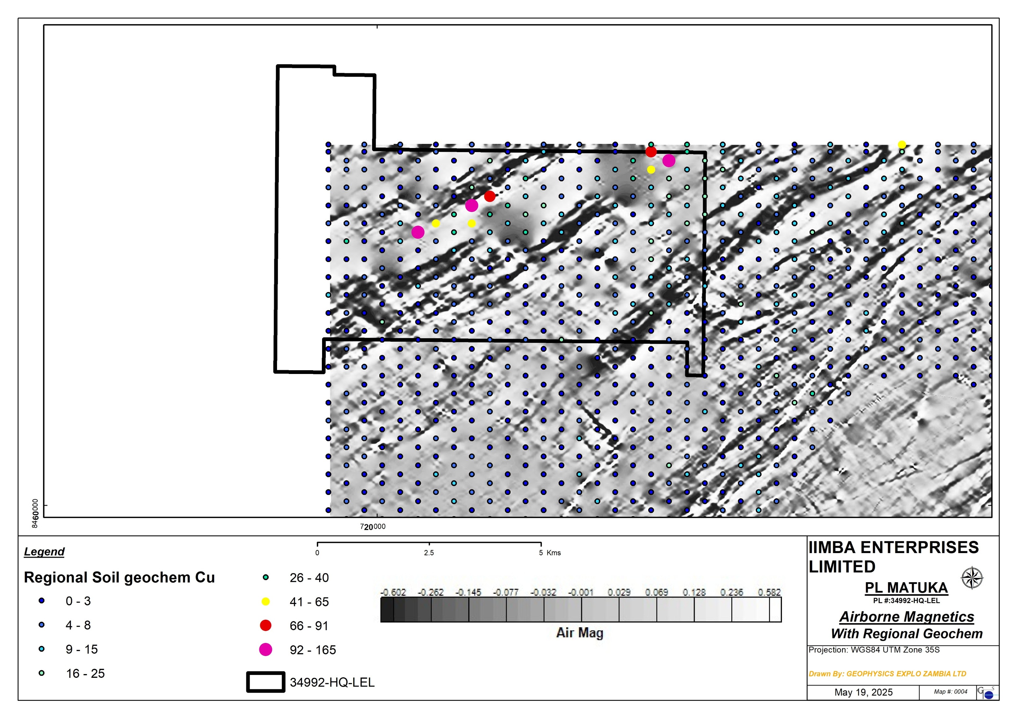
- Magnetics surveys indicates that the Matuka deposit occurs along NE trending shearzones within a low magnetic zone.
- More drilling is planned as only 1.2km out of the 3.3km strike of the target has been drill tested and so far has yielded post results.
Location
- Located on the boundary of Mkushi – Kapiri Mposhi Districts, Central Province of Zambia.
- 34km NE of Kapiri town and 35km SW of Mkushi town.
- Located 10km NW of the Mkushi Copper Mines (31.6MT @ 0.62% Cu) operated by Shi & Yan.
- Access to the area is via the T2 Kapiri Mposhi – Nakonde tarred road and a branch off at Mpula D209 gravel road to the license area. License area is accessible throughout the year.
License
- The Matuka license (34992-HQ-LEL) is one of the three adjacent large scale exploration licenses wholly owned by Iimba Enterprises Ltd (Iimba), the other adjacent licenses being 38494-HQ-LEL & 39628-HQ-LEL.
- The Matuka license was granted on 26th April 2024 for a period of 4 years with an option for renewal.
- 45.39km2 area extent.
Geology
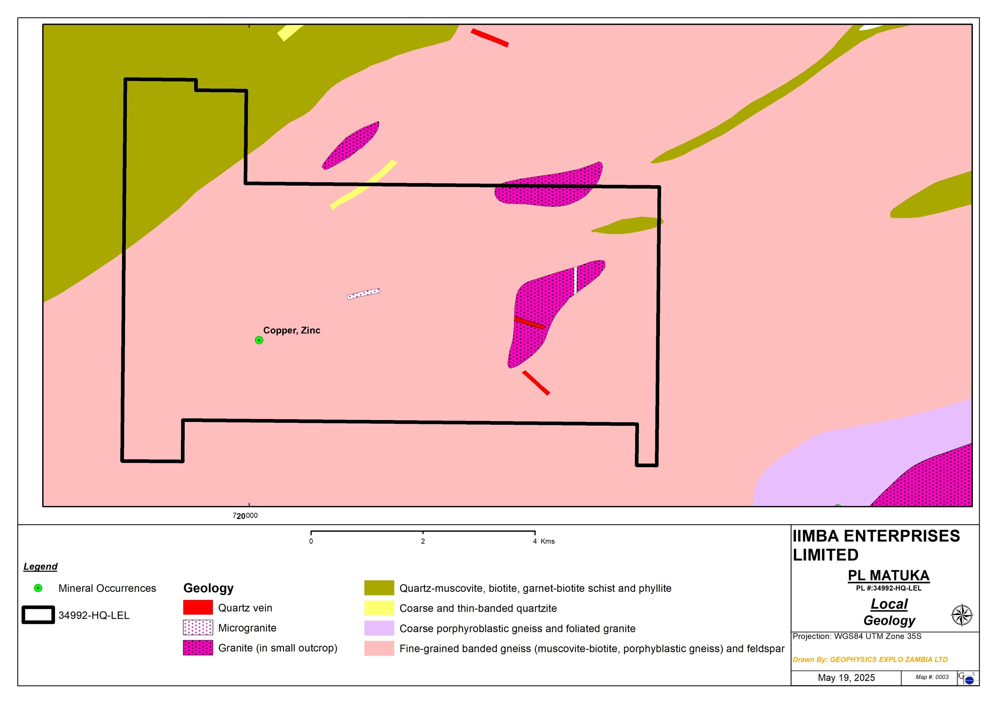
- situated on the southwestern end of the Mesoproterozoic Irumide Belt, a northeast-trending fold and thrust belt that stretches from central Zambia to the Zambia–Tanzania–Malawi border in the northeast.
- Lithologies in the Irumide belt comprise a Mesoproterozoic complex of gneisses and granitoids and a supracrustal succession of quartzites and pelites.
- The area is largely underlain by NE trending Mkushi Gneiss Formation of the Basement Complex comprising of banded gneisses and porphyblastic gneisses, and is unconformably overlain by quartz-muscovite, biotite, garnet-biotite schists of the Muva Supergroup. Swarms of felsic intrusives comprising of granites, aplites, pegmatites and microgranites intrude the Mkushi Gneiss complex along NE trending shearzones.
- A Cu/Zn occurrence was mapped by GSD within the tenement.
Historical Exploration
- The Matuka area was part of the license that was explored by African Eagles Resources Plc (Katanga Resources) of UK between 2007 and 2010, though the main focus for African Eagle was the Mkushi deposit 10km to the SE.
- The area was covered by airborne magnetics and regional geochemistry (400mx400m) carried by African Eagle in the Mkushi area.
- Cu anomalous zones were defined along strong NE trending low magnetic lineaments (shearzones). One in the central & the other in the east.
- An infill soil geochem followed by IP was carried out over the central anomaly.
Infill Geochem Cu + IP Chargeability by African Eagle
- The infill geochem (200mx200m) defined Cu, Zn & Pb anomalies corresponding with chargeable and conductive responses defined by IP/RES surveys.
- The highly anomalous trends appear to converge westward. They are sub-parallel in an easterly direction and correlate well with magnetic lows within the broader magnetic low.
- Strike length of at least 2km of this anomalous zone was defined.
Infill Cu Geochem + Resistivity by African Eagle
IP Model Section/Drill Holes by African Eagle
- A number of drill holes were generated by African Eagles to test the anomalies. The drilling could not go ahead as a result of African Eagle pulling out of Zambia in 2012.
Exploration Work Completed By Iimba
- Iimba managed to acquire the exploration data from African Eagle and continued exploration from where African Eagle left.
- Detailed soil geochemistry over the central Matuka target.
- IP survey over the central Matuka target.
- Radiometric Survey over the central Matuka target.
- Ground magnetic survey over the Matuka target.
- Diamond drilling testing selected targets for mineralisation.
- EPB in progress awaiting decision later from ZEMA.
Detailed geochemistry
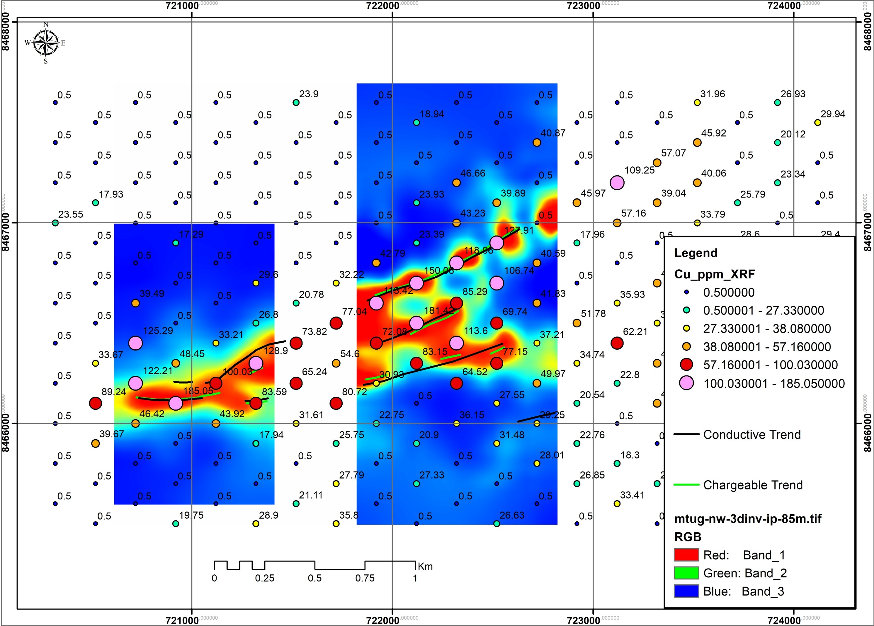
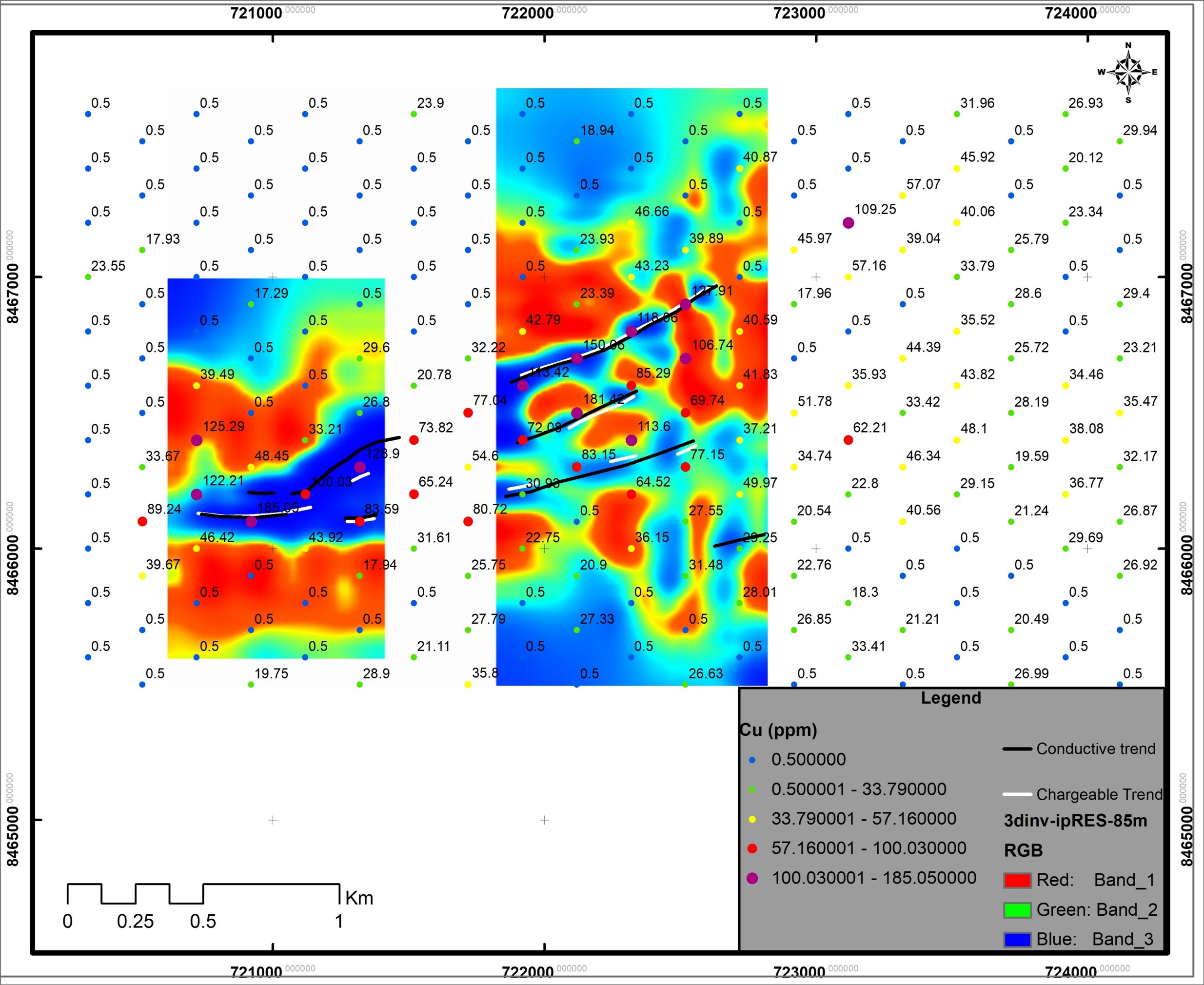
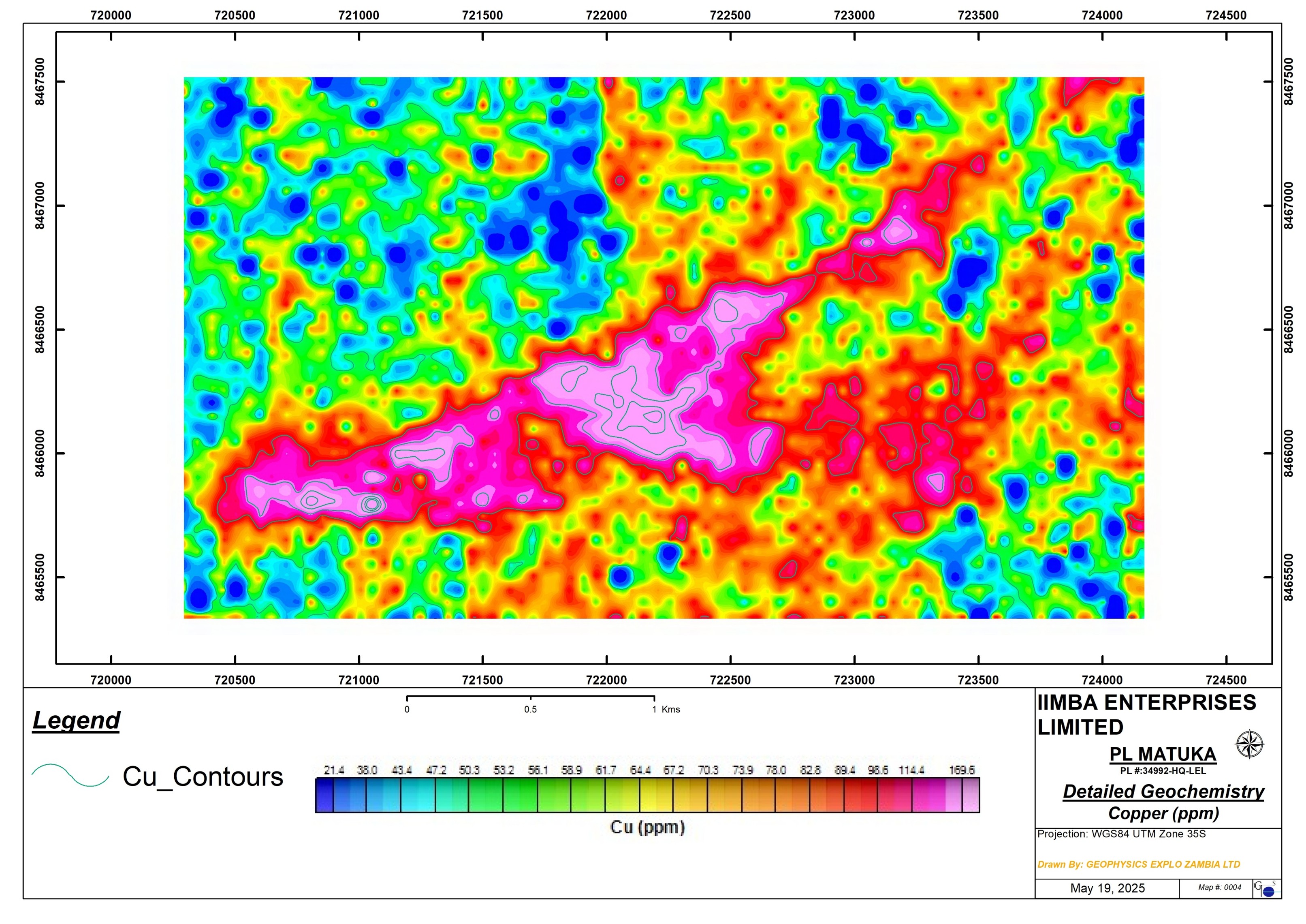
- A total of 3,612 primary samples were sampled over the Matuka target by Iimba on 50mx50m grid.
- The results defined a 3.3km ENE striking Cu (slide on right), Zn and Pb anomaly.
- A peak value of 887ppm Cu was recorded from soil geochemistry which is considerably high.
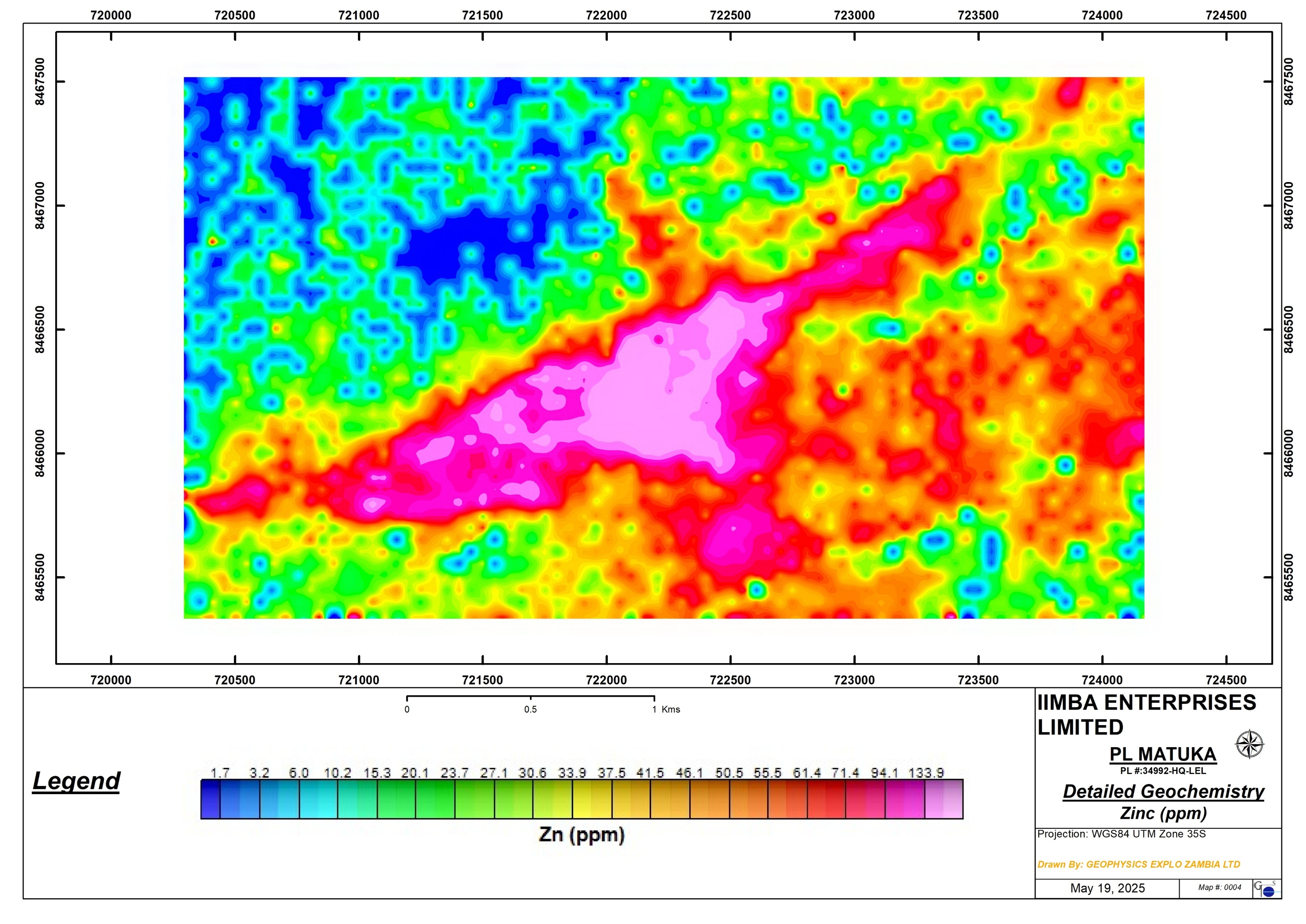
Soil Geochemistry Zn
- Spatial distribution of Zn along the same ENE trend as Cu.
- A peak value of 468ppm Zn was recorded from the detailed soil geochemistry
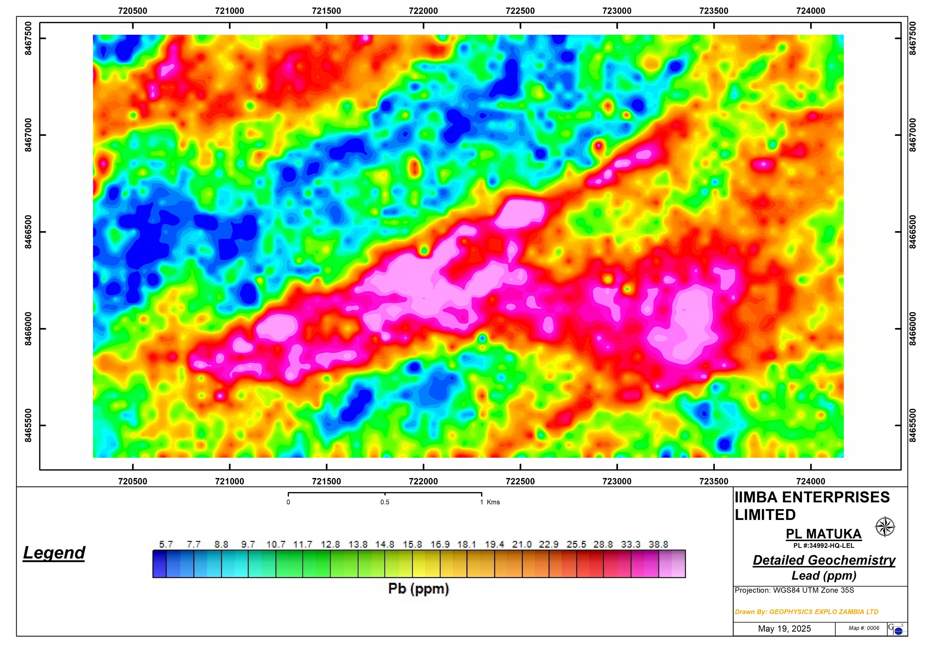
Soil Geochemistry Pb
- Pb anomaly on the same ENE Cu-Zn anomaly.
- Peak value of 111ppm Pb recorded from the detailed Soil Geochem.
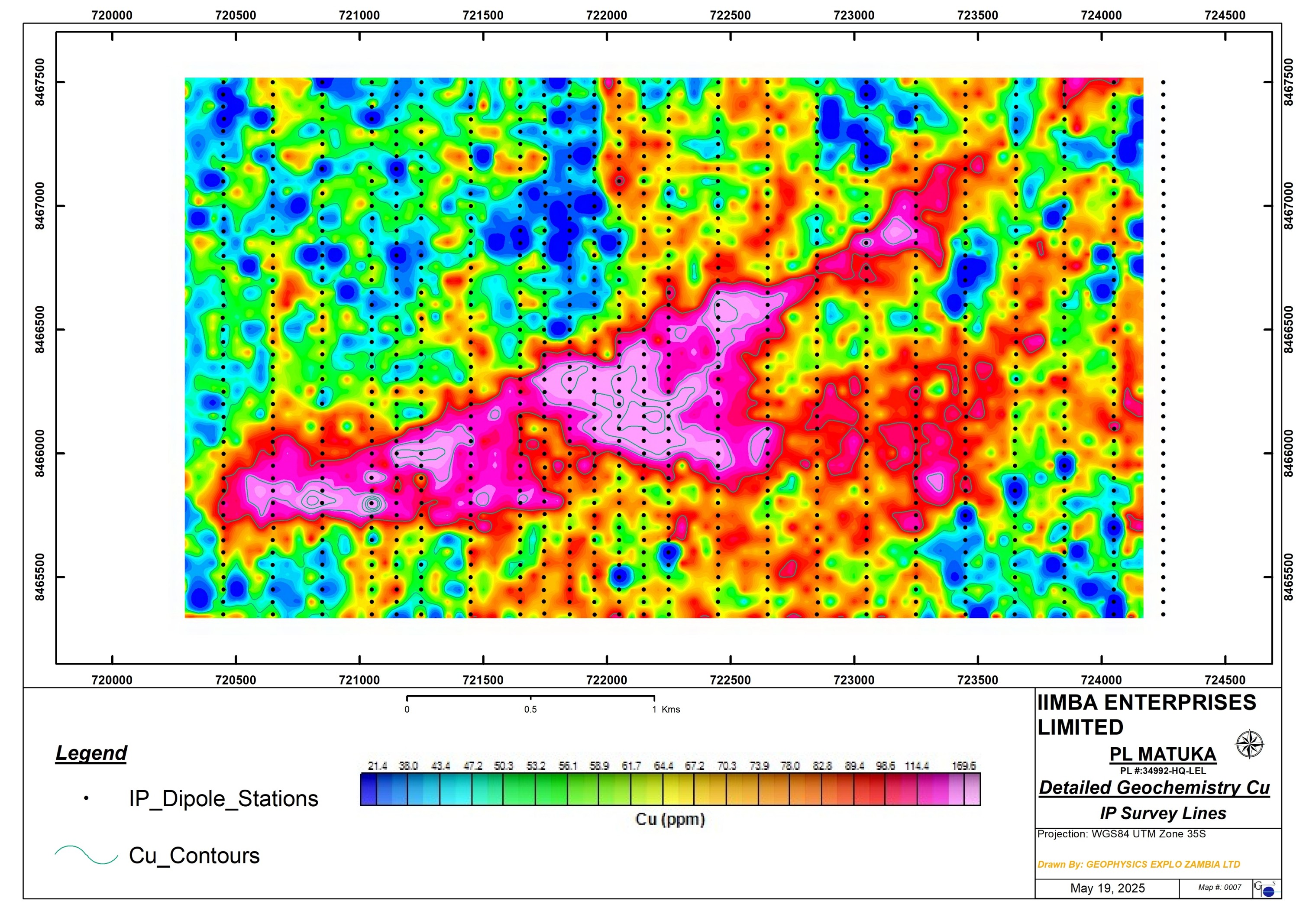
Induced Polarisation Survey (IP)
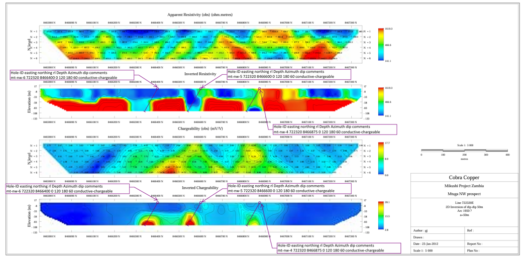
- An IP dipole dipole survey was carried out over the Matuka geochem anomaly (slide on right) in order to map disseminated Cu sulphides in the subsurface.
- A total of 23 lines were surveyed totaling 50km lines, covering the entire 3.3km geochem anomaly strike.
- Chargeability and resistivity were measured at the same time.
- All the 23 lines had strong chargeability and conductive responses over the geochem anomaly.
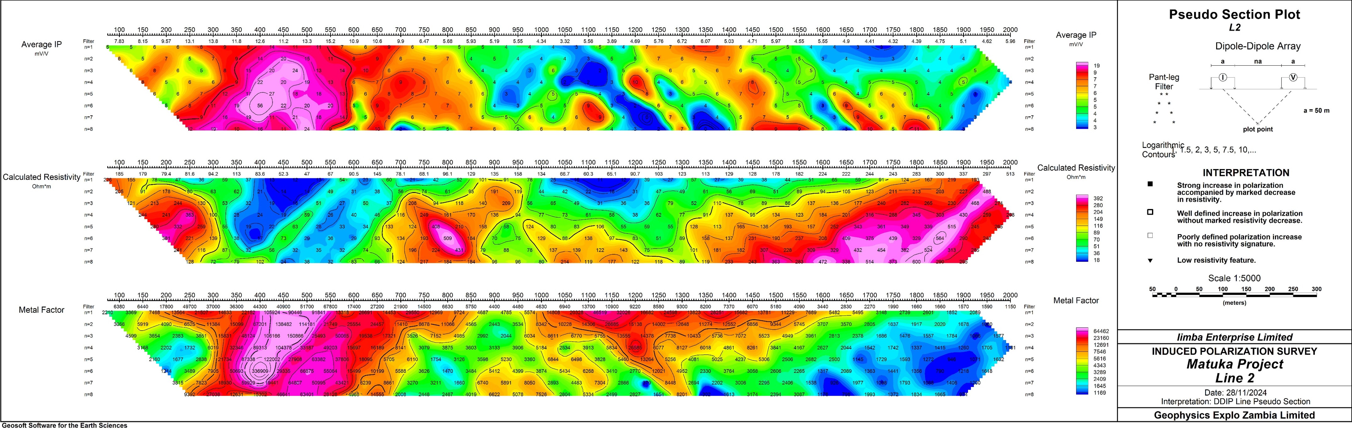
IP L2
IP anomalies characterized by high chargeability corresponding with low resistivity (conductors, disseminated sulphides)
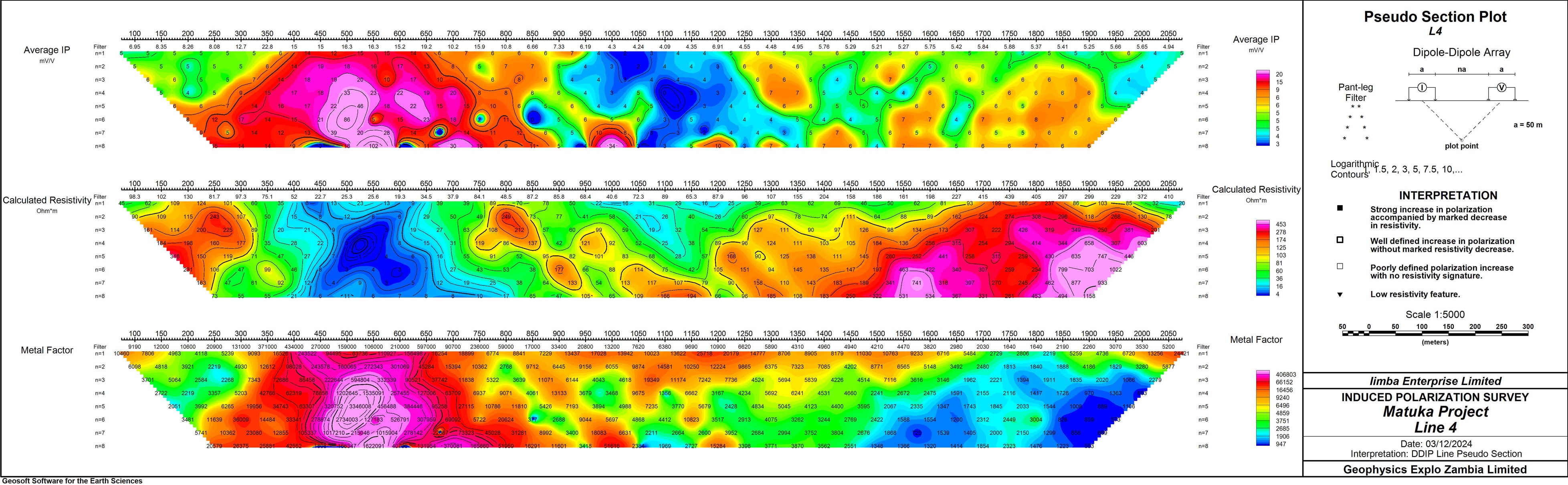
IP L4
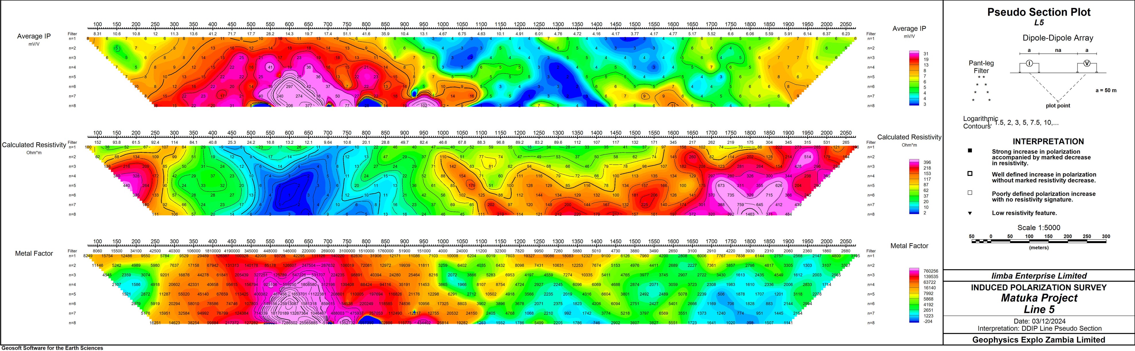
IP L5
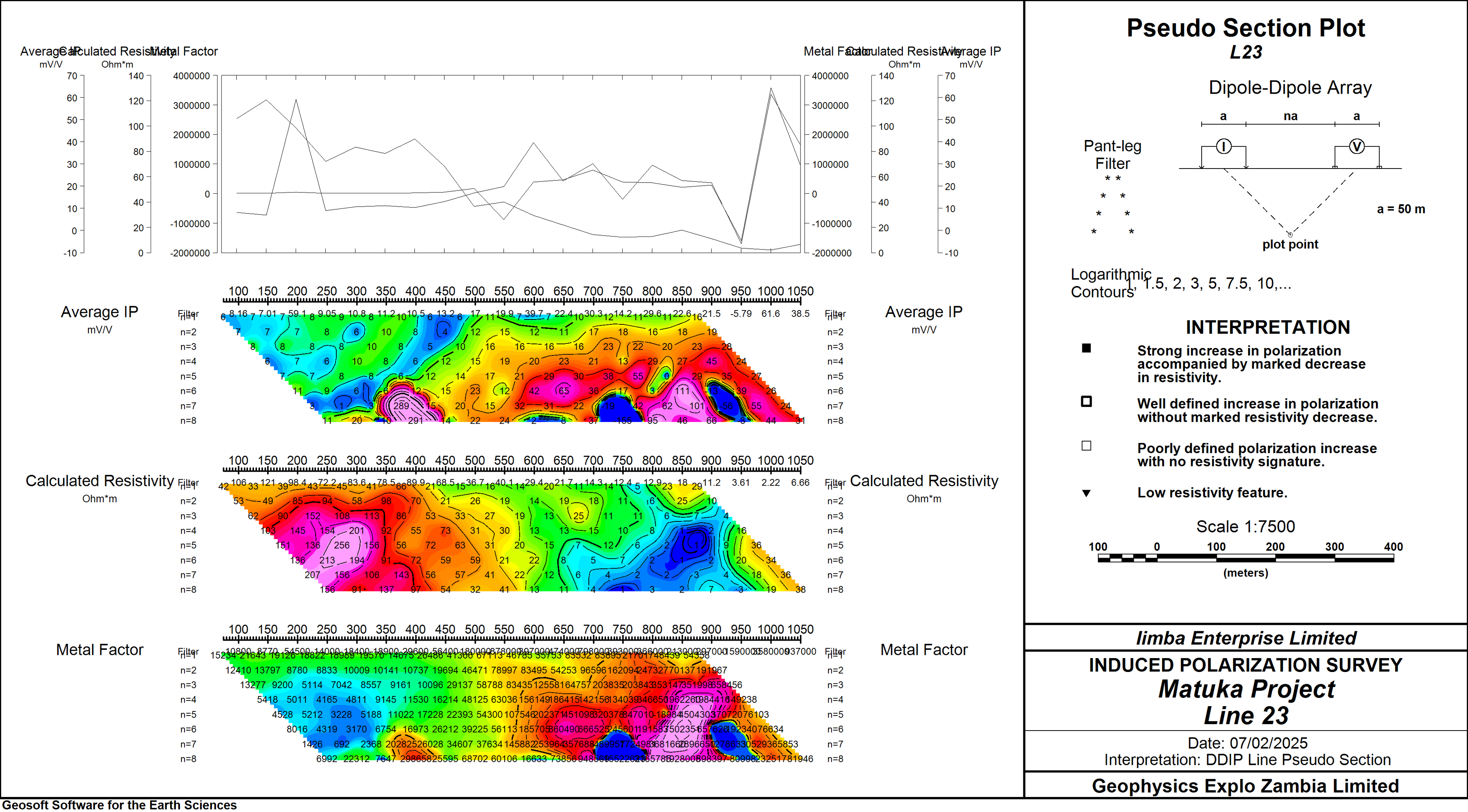
IP L23
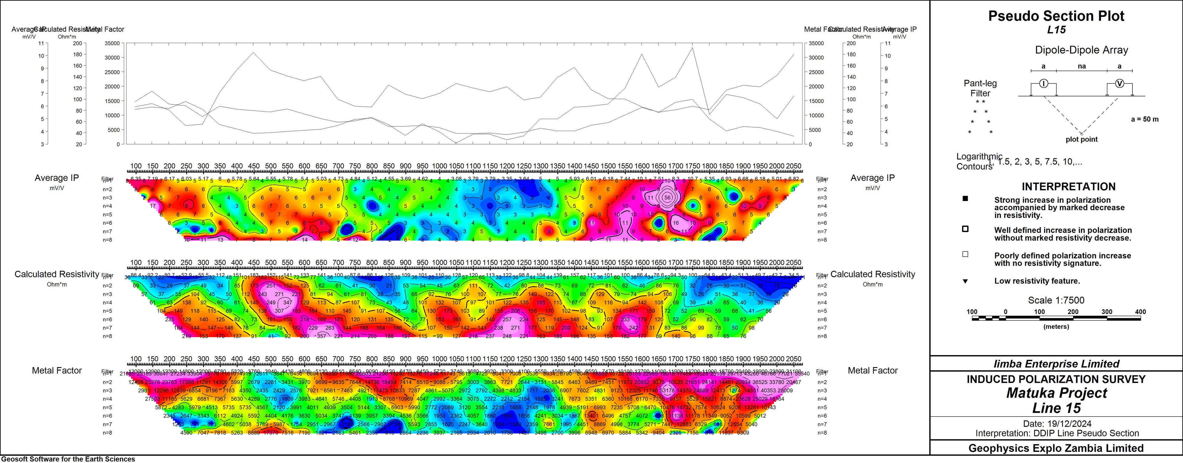
IP L15
further east, shallow IP chargeability anomaly
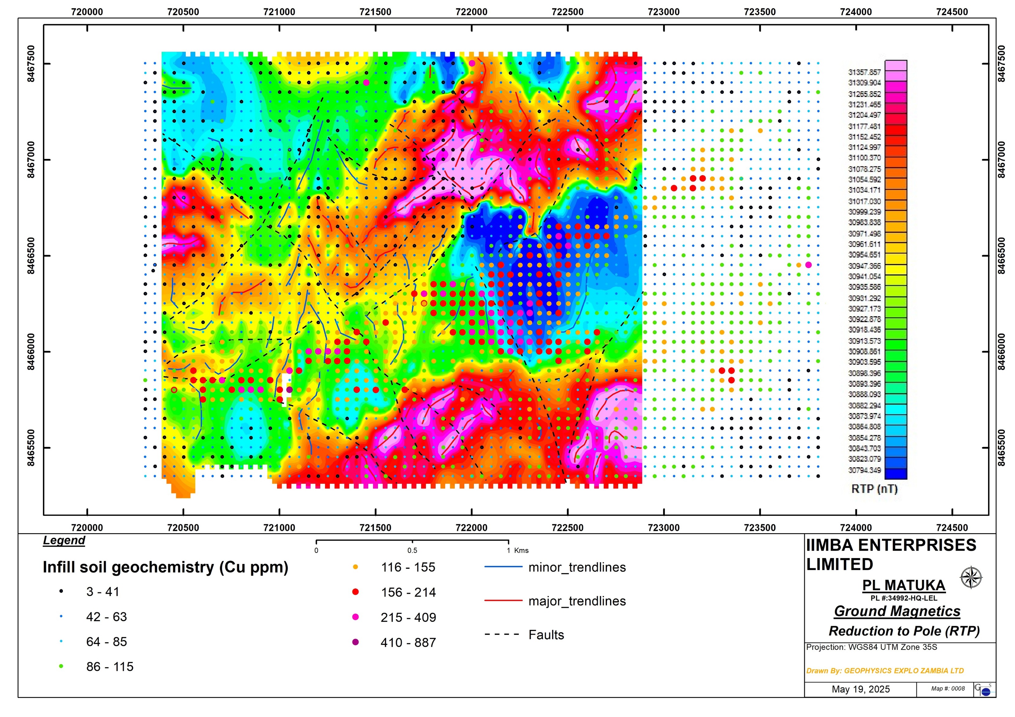
Ground Magnetic Survey
- A ground magnetic survey was carried out across the Matuka target for structural mapping purposes.
- The survey was carried on 50m line spacing and 10m station spacing, a total of 150km lines were surveyed.
- The survey indicates the target areas is cross-cut by NW trending and NE trending faults.
- The Cu soil geochem anomaly is confined to a low magnetic zone (shearzone).
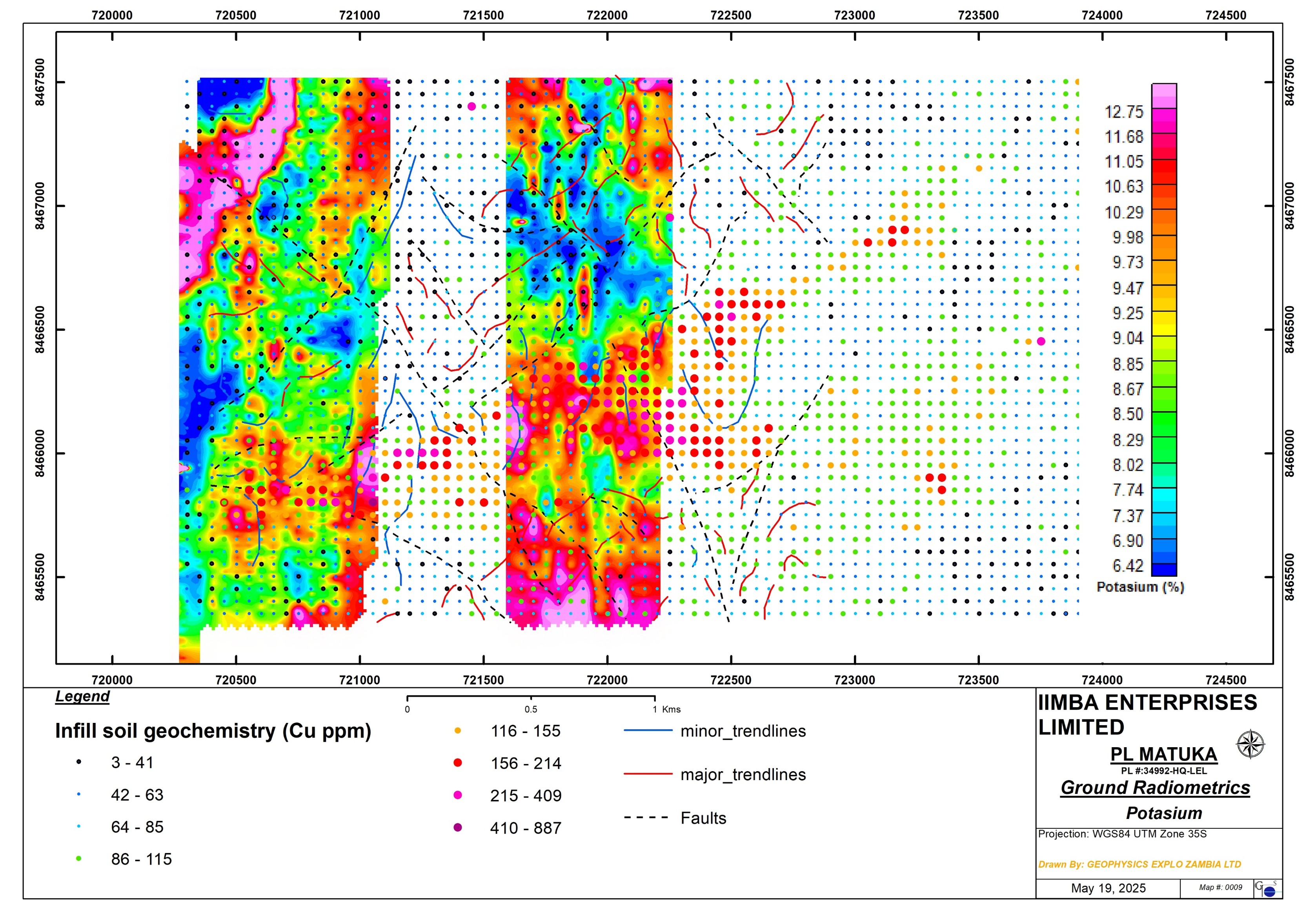
Radiometrics
- A ground radiometric survey was carried out over the Matuka target in order to map alteration zones due hydrothermal activities that may be associated with mineralizing fluids.
- The survey was undertaken on 50m line spacing and 10m station reading spacing grid. A total of 80km lines were covered.
- The radiometric results the Cu geochem anomaly corresponding to elevated radiometric potassium, possible hydrothermal alteration.
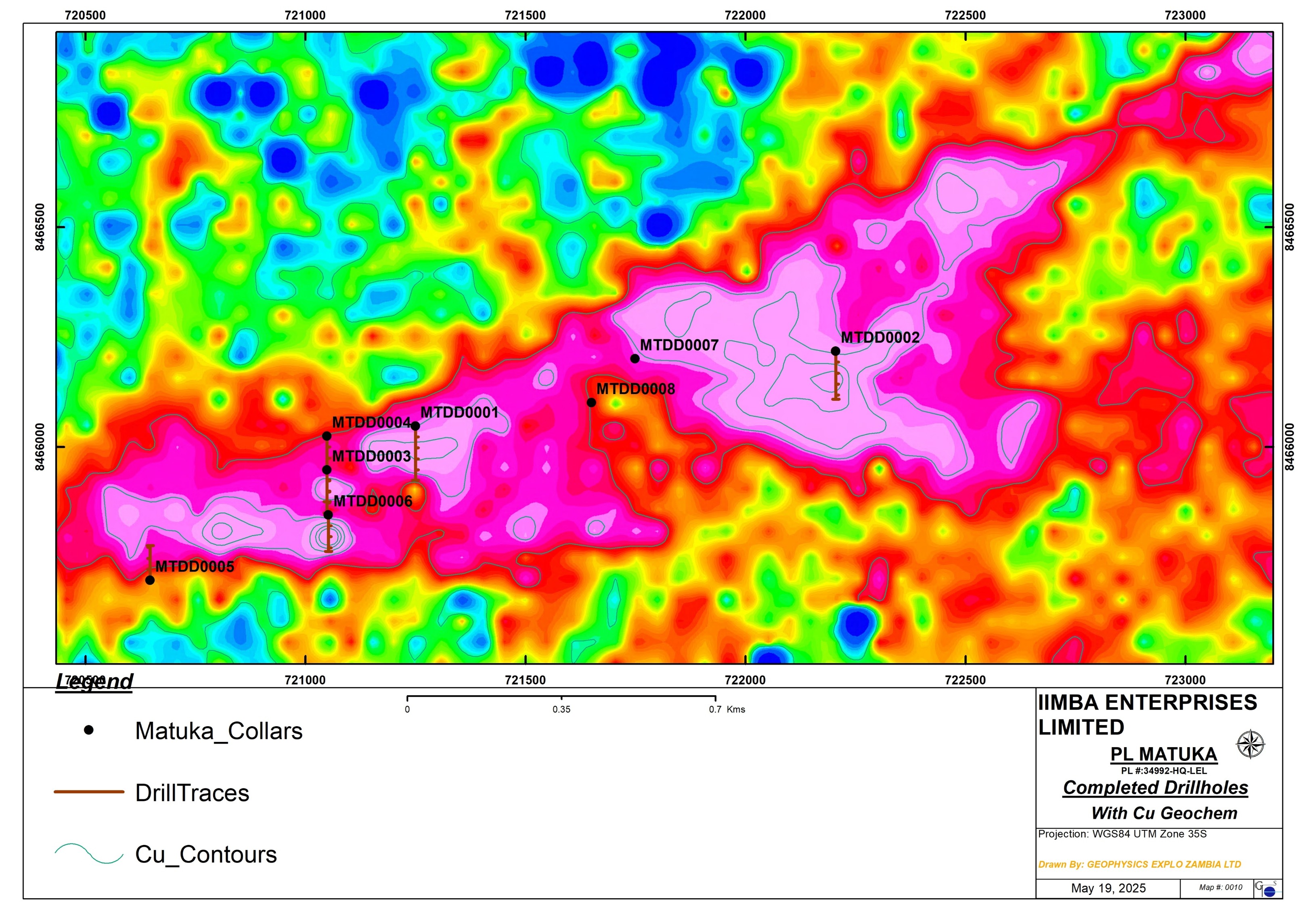
Diamond Drilling
- A diamond drilling programe was undertaken to test the geochemistry and IP anomalies for mineralisation across the Matuka target.
- 8 drillholes have been drilled so far totaling 1,749.6m.
- The drillcore samples were shipped to ALS Chemex lab for multi-element analysis.

Key Intersections - MTDD0001
- Targeting IP chargeability and conductivity at depth on Line 5.
- Intersected two zones of mineralisation; shallow in the weathered zone and at depth (chalcopyrite).
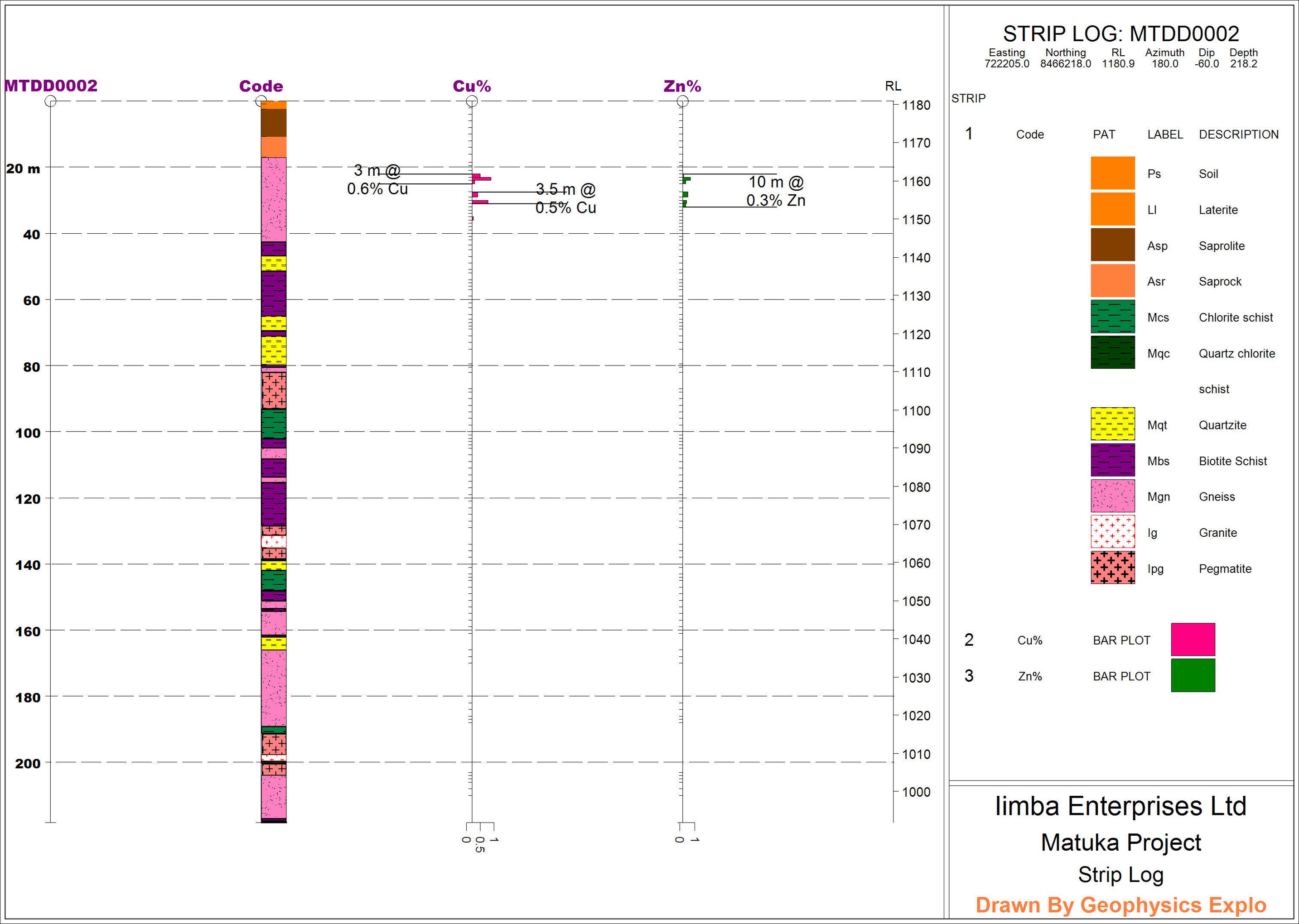
MTDD0002
- Drilled across the soil geochem anomaly.
- Intersected shallow oxide mineralisation in the gneiss.
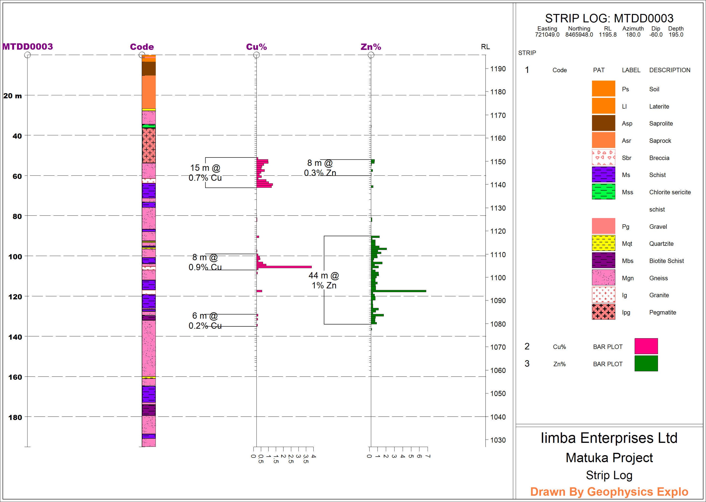
MTDD0003
- Drilled to test IP chargeability and conductivity on Line 4.
- Intersected two zones of sulphide mineralisation
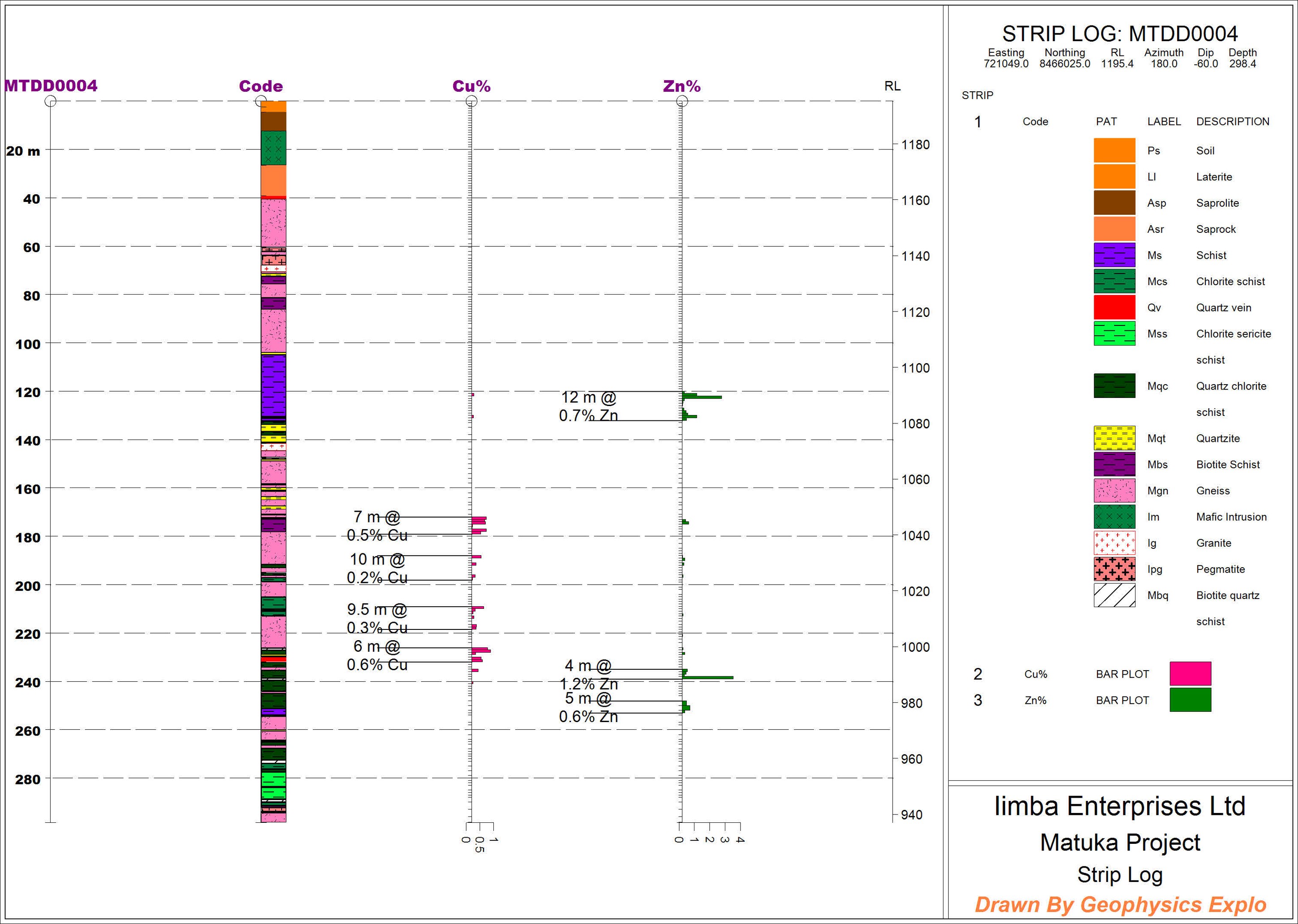
MTDD0004
- Drilled downdip of MTDD0003, also to test the IP chargeability and conductivity at depth on Line 4.
- Intersected sulphide mineralisation at depth.
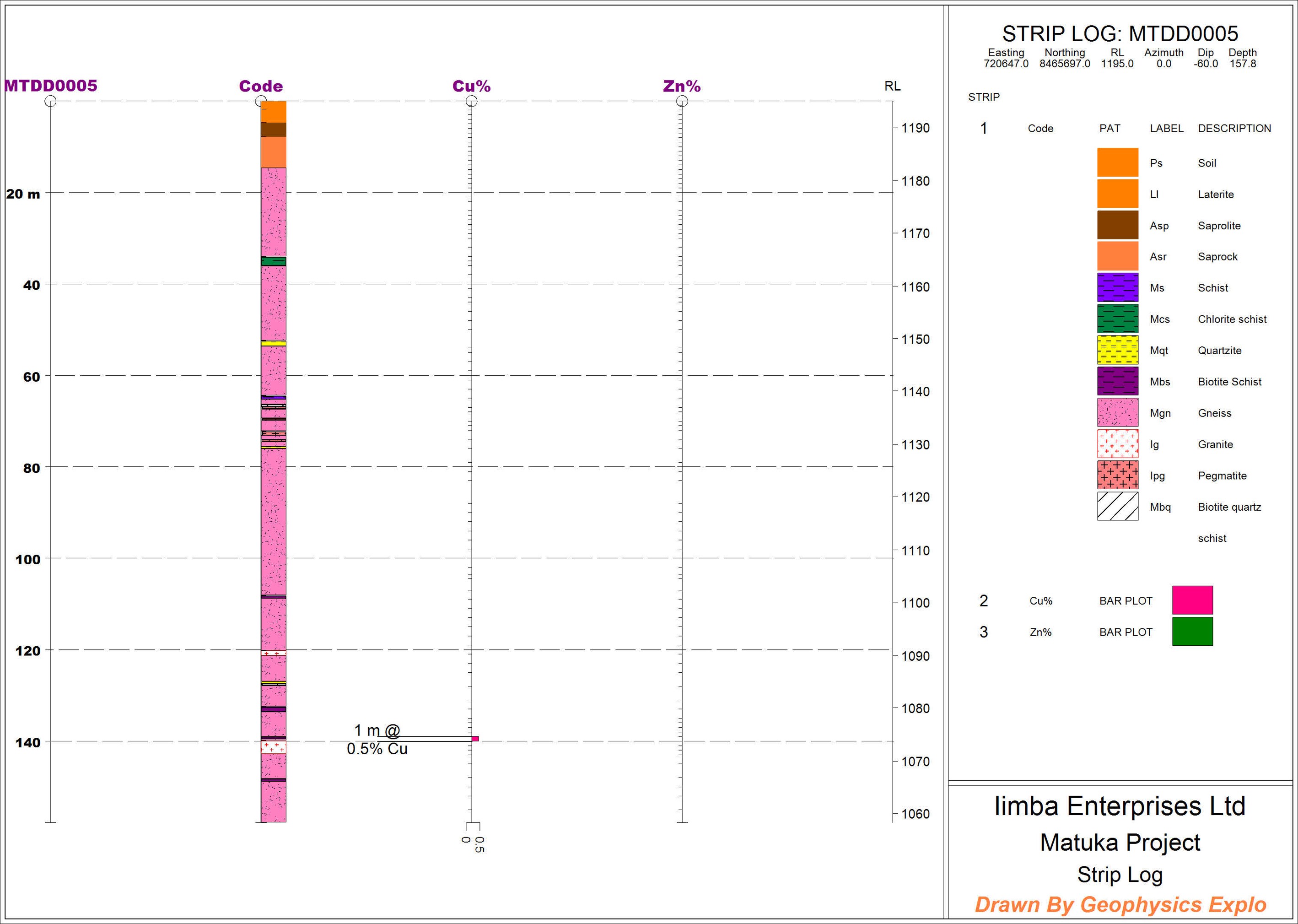
MTDD0005
- Drilled to test the deep seated IP chargeability and conductivity anomaly on Line 2.
- Did not reach the target depth.
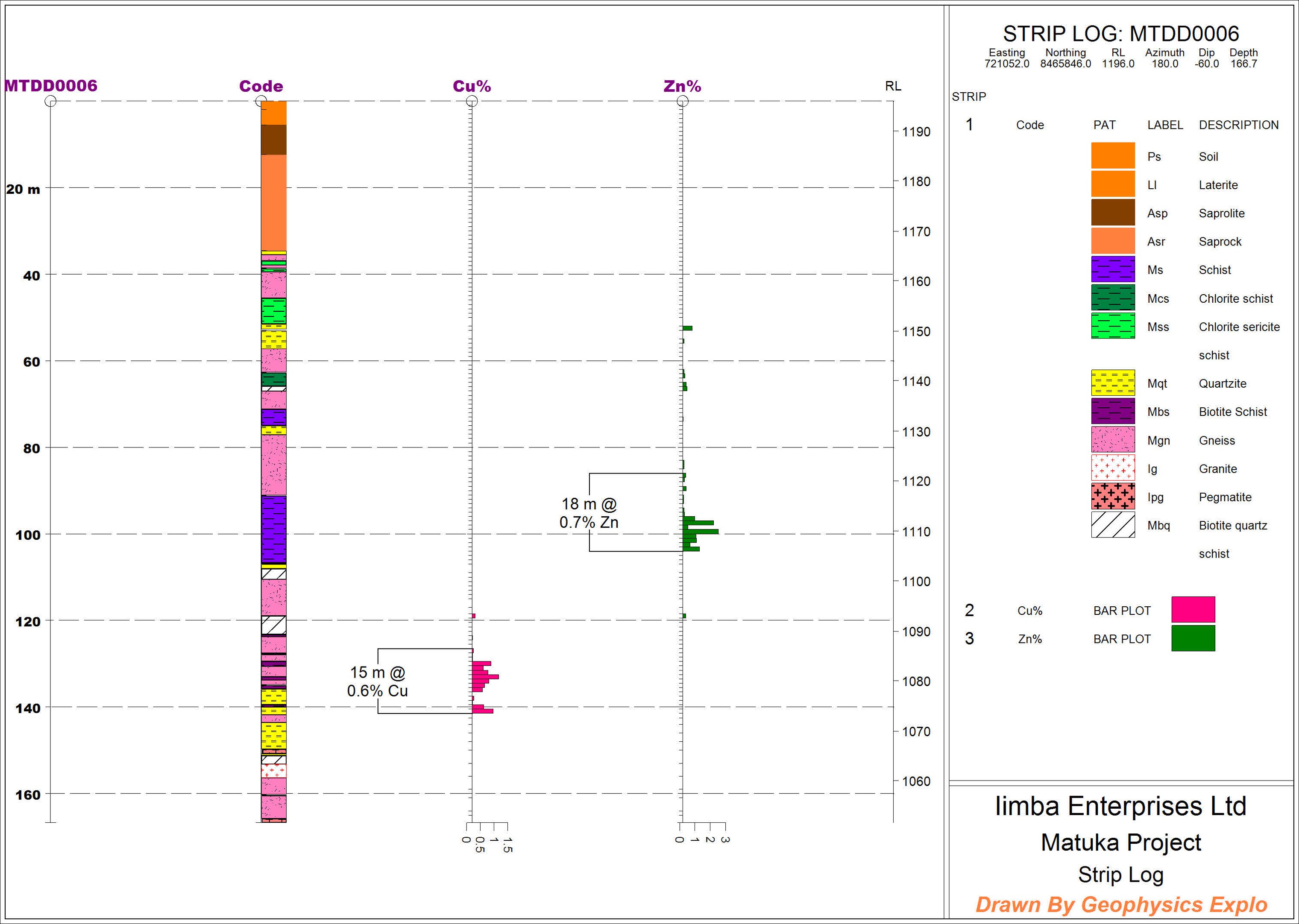
MTDD0006
- Drilled updip of MTDD0003 on Line 4.
- Intersected sulphide mineralisation at depth, most likely another mineralized horizon not intersected by drillhole MTDD0003.
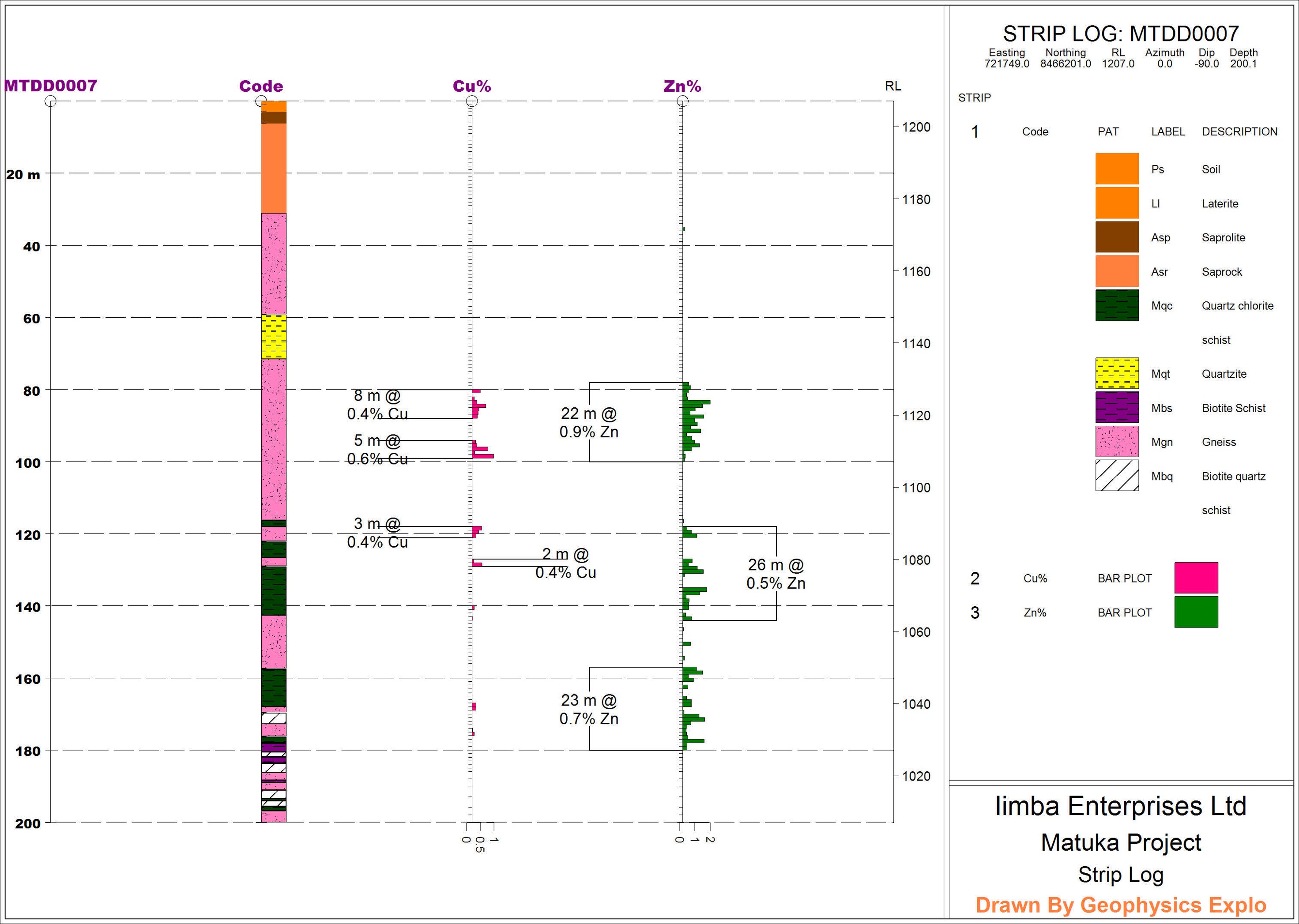
MTDD0007
- Drilled vertical to intersect a deep seated south dipping IP chargeable & conductive zone on Line 23.
- Intersected sulphide mineralisation.
Mineralisation
- Chalcopyrite is the main Cu ore mineralisation hosted altered schist, biotite schist and sheared gneisses. The Chalcopyrite occurs with pyrite.
- Mineralisations occurres as disseminations, in veins, blebs on fracture planes.
- Massive pyrite and pyrrhotite is intersected below the main orezone.
- Cu mineralisation is associated with chlorite alteration in the schist and silification in the gneiss.
- Mineralisation has been confirmed 1.2km along strike so far. 2.1km strike remain untested.
Planned Further Exploration Work
- Now that mineralisation has been confirmed. The next phase of drilling will focus on drilling along section lines as well as testing along strike.
- 6,000m of diamond drilling along section lines would be required to fully evaluate the Matuka project. This will include drilling some of the holes that were previously generated by African Eagle Resources.
- Extend the infill soil sampling and IP survey over the eastern target of Matuka and possibly sample 38494-HQ-LEL.